

The wildfire danger level is MODERATE for south of Lake Athabasca and HIGH for north of Lake Athabasca within the Fort McMurray Forest Area.
Due to significant rain received over the past few days, the fire advisory and fire restriction has been rescinded for the Fort McMurray Forest Area.
MCX002 - Cattail Complex
Wildfires MWF047, MWF077, and MWF079 are part of the Cattail Lake Complex. All three wildfires were caused by lightning and are classified as being held. Being held means that given current weather conditions and resources, the wildfire is not anticipated to grow past expected boundaries.
MWF047 is 110,962 ha in size and is located 53 km east of Fort McKay, 68 km northeast of Fort McMurray, and 6 km northeast of local industrial facilities.
MWF077 is 18,453 ha in size and 38 km northeast of Fort McMurray, 46 km from Fort McKay, and 6.5 km from local industrial facilities.
MWF079 is 7,948 ha in size and is located near the Saskatchewan border.
MCX003 - Algar Lake Complex
Wildfires MWF069, MWF086, and LWF165 make up the Algar Complex.
MWF069 is classified as under control and is located 10 km west of Highway 63 and 40 km southwest of Fort McMurray. It is 17,183 ha in size.
MWF086 is classified as being held and is located 37 km southwest of Fort McMurray. It is 2,251 ha in size.
MCX004 - Rabbit Lake Complex
Wildfires MWF060, MWF074, and MWF078 are part of this complex.
MWF060 is classified as out of control and is located about 25 km northeast of Chipewyan Lake. It is estimated to be 27,392 ha in size. This wildfire was caused by lightning.
MWF074 is classified as being held and is located northeast of MWF060. It is 297 ha in size and was caused by lightning.
MWF078 is classified as being held and is located about 25 km east of Chipewyan Lake. It is 3,000 ha in size.
FORT MCMURRAY FOREST AREA WILDFIRE UPDATE
There are currently 19 active wildfires in the Fort McMurray Forest Area. Currently, one is out of control, 12 are being held, and six are under control.
Since January 1, 2024, 96 wildfires have burned approximately 290,513 hectares (ha) in the Fort McMurray Forest Area.
MWF094 was discovered August 12 and is located approximately 24 km southwest of Fort McMurray. It is classified as being held and is estimated to be 0.5 ha in size. The cause of this wildfire is under investigation.
MWF045 was discovered on July 2 and is approximately 23 km south of the Wood Buffalo National Park border. It is classified as being held and is estimated to be 5,454 ha in size. This wildfire was caused by lightning.
MWF061 was discovered on July 7. It is approximately 110 km northeast of Fort McKay and 13 km from the Birch Mountain Wildland Provincial Park. It is classified as being held and is estimated to be 1514 ha in size. This wildfire was caused by lightning.
MWF063 was discovered on July 9 and is 60 km southwest of Camsell Portage (Saskatchewan) and 65 km northeast of Fort Chipewyan. It is classified as being held and is estimated to be 29,676 ha in size. This wildfire was caused by lightning.
MWF068 was discovered on July 10 and has crossed over into the High Level and Slave Lake forest area borders. It is classified as being held and is estimated to be 31,297 ha in size. This wildfire was caused by lightning.
MWF080 was discovered on July 14 and is located in the area between Gipsy Lake, Garson Lake and the Alberta/Saskatchewan border. It is classified as being held and is estimated to be 3,570 ha in size. This wildfire was caused by lightning.
MWF043 was discovered on July 3 and is approximately 22 km northwest of Bitumount. It is classified as under control at 427 ha in size. This wildfire was caused by lightning.
MWF056 was discovered on July 3 and is located approximately 41 km north of the Cattail Complex (MCX002). It is classified as under control at 2050 ha in size . This wildfire was caused by lightning.
MWF064 was discovered on July 9 and is located on Bustard Island, approximately 2 km northwest of the Bushland Island remote forest recreational reserve. The island is 23 km northeast of Fort Chipewyan. It is classified as under control at 884 ha in size. The cause of this wildfire is under investigation.
MWF081 was discovered on July 16. It is located on Burntwood Island, 39 km northeast of Fort Chipewyan. It is classified as under control and is estimated to be 779 ha in size. This wildfire was caused by lightning.

See the latest fire danger maps.

You can get a free fire permit online.
You will need:
- either an Alberta.ca Account or Alberta.ca Account for Organizations
- a description of the burn material(s)
- the location(s) of the burning activity
- any applicable photos or attachments
If you need help, see the Online Fire Permit System User Guide.
You can also request a fire permit by contacting your local forest area office.
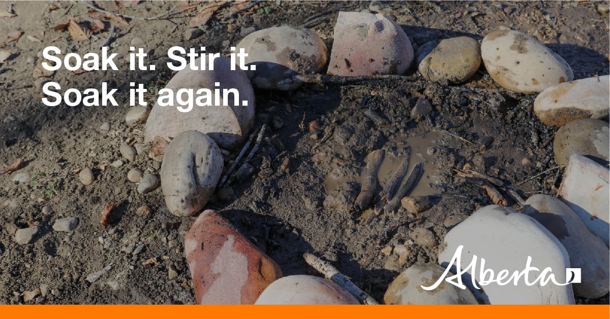
When you're done with your campfire, always remember to soak it, stir it and soak it again.
- Let the fire burn down before you plan on putting it out. Spread the embers within the fire pit, then add water or loose dirt, and stir.
- Expose any material still burning. Add more water and stir again until you can no longer see smoke or steam. Do not bury your fire as the embers may continue to smoulder and can re-emerge as a wildfire.
- Repeat until your campfire is cool to the touch.
- If your fire is out, you should not be able to feel any heat from the ashes.
See the safe campfires brochure for more information.
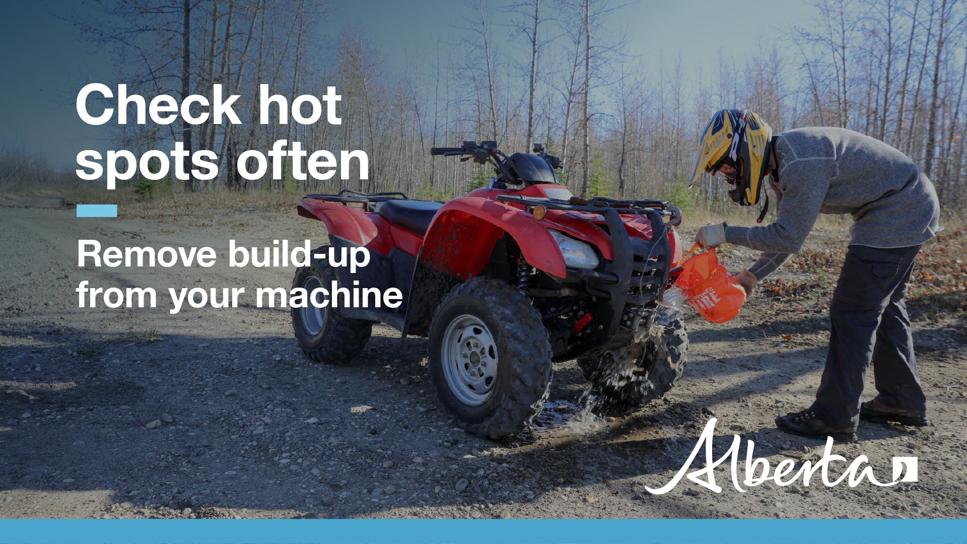
OHV SAFETY
Always be cautious when recreating outdoors.
Off-highway vehicles (OHVs) have exhaust systems that get hotter than 200°C. At these temperatures, built-up materials (such as grass, muskeg, moss, or other debris) can heat up, smoulder and ignite.
These can fall to the ground as you are riding, starting a wildfire.
See OHV safety tips.
CONTACT:

RELATED INFORMATION
- Alberta Wildfire
- Alberta Fire Bans
- FireSmart in Alberta
- Alberta Emergency Alerts
- Air Quality Health Index
- Wildfire Smoke and Your Health
- 511 Road Reports
- Emergency Preparation
Join the conversation on
![]()
![]()
![]()
DOWNLOAD OUR APPS
Alberta Wildfire App for Apple or Android and Alberta Fire Bans App for Apple or Android.