

The fire danger in the Fort McMurray Forest Area is overall VERY HIGH, with the exception of the area surrounding Lake Athabasca and to the north where the fire danger is EXTREME.
Please use caution when working or recreating in the outdoors. Always ensure you fully extinguish your campfire and if you see smoke or flame in the forest, call 310-FIRE (3473).
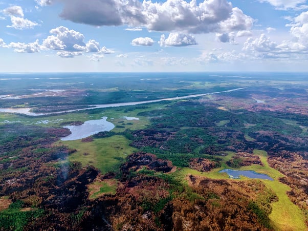
Today's aerial view taken near the southwest flank of the fire perimeter. (July 11, 2022)

A fire ban is in effect within the Fort McMurray Forest Area for the area north of Lake Athabasca. Please visit albertafirebans.ca to see a map of the exact area covered under this fire ban.
Under this ban:
- all existing fire permits are suspended.
Prohibited:
- wood campfires on public land, private land and provincial campgrounds
- backyard fire pits
- charcoal briquette barbecues
- fireworks and exploding targets
Allowed:
- propane or natural gas powered appliances
- indoor wood fires
If you see a wildfire, report it immediately by calling 310-FIRE.
The fire ban will remain in effect until conditions improve.
To view the ministerial order and maps, click here.
FORT MCMURRAY WILDFIRE UPDATE
Since January 1, 2022, there have been 44 wildfires in the Fort McMurray Forest Area burning a total of 53,263 hectares (ha).
MWF015 was detected on June 12 and located 24 km southeast of Fort Fitzgerald, 45 km southeast of Fort Smith and 115 km north of Fort Chipewyan. It is currently estimated to be 3,162 ha in size and classified as being held. This wildfire was caused by lightning. Another eight mm of rain fell on this fire yesterday.
MWF018 was detected on June 13 and is located 28 km southeast of Fort Fitzgerald, 43 km southeast of Fort Smith and 90 km north of Fort Chipewyan. It is currently estimated to be 2,842 ha in size and classified as being held. This wildfire was caused by lightning. Another eight mm of rain fell on this fire yesterday.
MWF022 was detected on June 13 and is located 60 km southeast of Fort Fitzgerald and 62 km northeast of Fort Chipewyan. It is currently estimated to be 15,656 ha in size and classified as being held. This wildfire was caused by lightning.
MWF033 was detected on June 30 and is located 30 km southwest of Fort Fitzgerald and 110 km north of Fort Chipewyan. It is currently estimated to be 1,853 ha in size and classified as being held. The fire has reached the west side of Leland Lake. The cause of this wildfire is currently under investigation. Another eight mm of rain fell on this fire yesterday.
MWF034 was detected on June 30 and is located 50 km southeast of Fort Fitzgerald and 90 km north of Fort Chipewyan. It is currently estimated to be 1,302 ha in size and classified as being held. The cause of this wildfire is currently under investigation.
Since these wildfires are located in remote areas where they do not threaten communities or resources, we allow the wildfires to play out their natural role onto the landscape under the watchful eye of experienced fire managers. Using this wildfire management strategy has many benefits. It re-introduces fire onto the landscape, creates a break in the continuous fuels, reduces the intensity of the fire, provides safety zones for our firefighting crews to work from and reduces the cost of fighting these wildfires.
These wildfire are actively monitored by firefighters on a regular basis and do not threaten any communities at this time.
To learn more about the classification of wildfires, please click here.
To view the wildfires on a map, check out the new wildfire dashboard. It provides up-to-date wildfire information at the click of a button. This interactive tool displays important statistics on the number of active wildfires in the province, sizes, locations, suspected causes and more.
WILDFIRE OF NOTE
MWF031 was detected on June 25 and is located 21 km north of Fort Chipewyan. The fire remains on the edge of Flett Lake and is growing towards the north. The wildfire is estimated to be 24,930 ha in size and was caused by lightning. It remains classified as being held. This wildfire does not threaten any community at this time. The fire has not grown towards the south and therefore has not gotten closer to Fort Chipewyan or the airport.
Today minimal fire activity was observed on wildfire MWF031, which received 1.2 mm of rain over the last 24 hours. A small lightning-caused wildfire (MWF041) was detected on the evening of July 9, east of MWF031. Firefighters responded with the support of helicopters and the fire is now extinguished. More lightning-caused wildfires may be detected in the coming days.
Today, firefighters continued to work on strengthening the containment line to the south of the fire. They were assisted by helicopter bucketing operations. The containment line has been established along a natural break located between Flett Lake and the Des Rochers river. It's intended to prevent the wildfire from spreading south.
Another group of firefighters continued to work on structure protection. They were busy maintaining equipment such as pumps, hoses and sprinkler systems on buildings identified as being directly threatened by the wildfire. The protection plan for Fort Chipewyan, the airport and the airport road is now complete. The protection plan for Dog Head is close to completion.
Tomorrow, dry conditions are expected. Temperatures are forecasted to be in the high 20s with humidity around 30%. Winds are expected to come from the southwest tomorrow at 20 km/h, with wind gusts up to 35 km/h, which will continue to push the wildfire towards the northeast. Weak inversions may continue to develop overnight, which could bring smoke into the community. The inversion is expected to break by 11 a.m., allowing the smoke to dissipate.
Tomorrow, firefighters and helicopters will continue their indirect attack on the wildfire. A total of 45 firefighters and six helicopters are assigned to wildfire MWF031 and stationed in Fort Chipewyan. Additional aircraft are available if needed in Fort McMurray.
Local aircraft operators, please be advised that a “notice to airmen” NOTAM is in effect for the area surrounding wildfire MWF031.
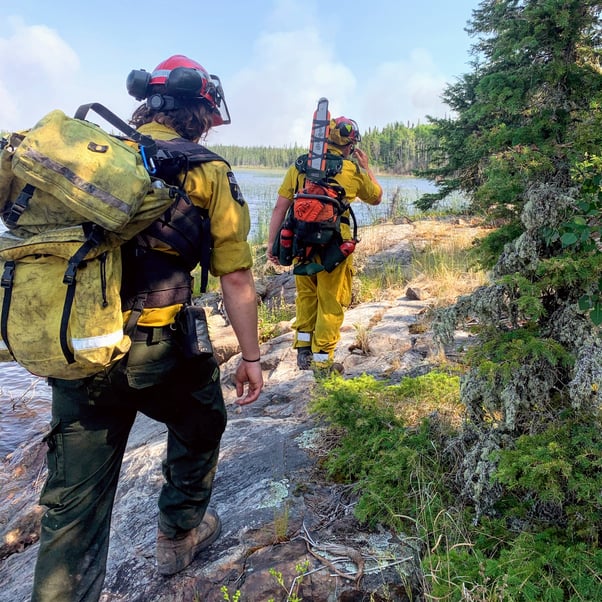 Firefighters continue to work on strengthening the south containment line. (July 11, 2022)
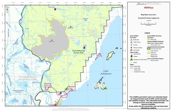
To view the map of MWF031 in full size, click here.
To view a map of all the wildfires in the area north of Lake Athabasca, click here.
SPECIAL AIR QUALITY STATEMENT IN EFFECT
A special air quality statement is in effect for many parts of the Fort McMurray Forest Area. You can view the statement by clicking here. To view the affected area, visit the interactive map by clicking here.
If you have smoke related concerns, we recommend that you visit the Alberta Health FAQs on wildfire smoke by clicking here. You can also visit firesmoke.ca to view current and forecasted smoke in your area.
A MESSAGE FROM THE REGIONAL MUNICIPALITY OF WOOD BUFFALO
There are currently no threats to any communities at this time.
Please visit www.rmwb.ca/fortchip for the latest joint update from the Athabasca Chipewyan First Nation, Mikisew Cree First Nation, Fort Chipewyan Métis and the Regional Municipality of Wood Buffalo.
In the event of an evacuation alert or order within the Regional Municipality of Wood Buffalo, we recommend that you download Alertable - Emergency Notifications.
To learn more about how you can protect your property from wildfire, visit the Regional Municipality of Wood Buffalo FireSmart website: www.rmwb.ca/en/fire-and-emergency-services/firesmart
Managing emergencies is all about planning for them in advance. Once a year, a review of the REMP and CEMPs is done to ensure they reflect all the needs of our region. To learn more about the Regional Emergency Management Plan, click here.
PROVINCIAL WILDFIRE UPDATE
Since January 1, 2022 in the Forest Protection Area, there have been 567 wildfires burning a total of 67,363 ha.
FIRESMART
Using FireSmart principles is becoming a way of life for many communities in North America. With so many neighborhoods threatened by wildfire each year, residents are taking action and reducing the risk to their homes, cabins and properties.
Being FireSmart doesn't have to be complicated and there are many resources to help you get started. You can check out some easy tasks by visiting firesmartcanada.ca, click here to watch a video or you can take the FireSmart Canada FREE one-hour course by clicking here.
REQUEST A FIRE PERMIT
Wildfire season in Alberta is from March 1 until October 31. During wildfire season, you are required to have a fire permit if you plan on burning in the Forest Protection Area, with the exception of a campfire.
To request a free fire permit online, visit the new portal. You will need a MyAlberta Digital ID to access the portal. Please note that you can still request your permit from the Fort McMurray forest office by calling 780-743-7125.
For more information regarding fire permits, you can view our video by clicking here.
For more information, please contact:
RELATED INFORMATION
Websites:
- Alberta Wildfire
- Alberta Fire Bans
- FireSmart in Alberta
- Alberta Emergency Alerts
- Air Quality Health Index
- Wildfire Smoke and Your Health
- 511 Road Reports
- Emergency Preparation
Social Media: