

Municipal Update
Municipal District of Greenview | May 17 @ 11:00am
UPDATE: The evacuation order for areas to the south of the hamlet of Little Smoky area was lifted at 9:00 a.m. for residents in the M.D. of Greenview south of the Hamlet of Little Smoky between Twp Rd 650 and Twp Rd 664 and Rge Rd 210 to Rge Rd 215 on both sides of Highway 43. A two hour evacuation notice is now in effect.
For the most up to date information on either situation, see the md.greenview.ab.ca or emergencyalert.alberta.ca
You can also follow the M.D. of Greenview on FaceBook, Twitter (@mdgreenview16) or Instagram (@md_greenview).
Town of Fox Creek | May 17 @ 11:00am
There has NOT been an evcuation order issued for the Town of Fox Creek. The Town is asking residents to be prepared. The Town is treating the wildfire situation seriously and stressing again that the Town is not being threatened at this time. Visit the Town website or see emergencyalert.alberta.ca under the MD of Greenview updates, for the most up to date information.
No one knows for sure when disaster will strike.
The one thing we can do is be prepared. Create your own 72-hour emergency kit, and you will have the necessary items to help you and your family until emergency responders can reach you. Visit www.aema.alberta.ca/72-hour-emergency-kit.

Wildfire Update
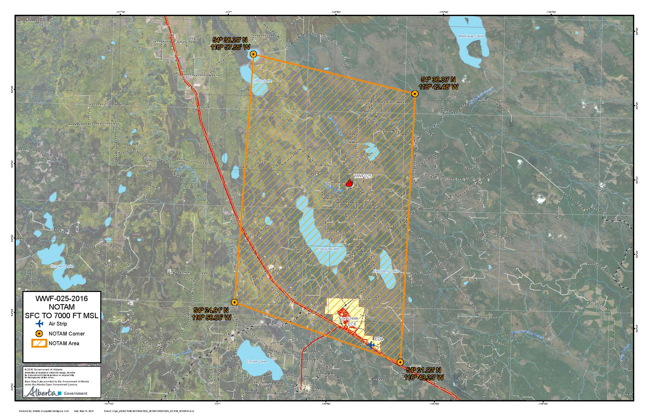
A NOTAM has been issued for the air space around the wildfire WWF025 for air operations. All aircraft require permission to enter the air space. It is in effect until May 24 at 12:00hrs. Read more here.
Whitecourt Forest Area Update | May 17 @ 9:00 a.m.
Wildfire in the Little Smoky area (WWF-025) - started at 1:00 p.m. May 15 and remains classified as OUT CONTROL. The wildfire did not grow over night, firefighters were able to get an accurate measurement of the wildfire perimeter today and it is 657.40 hecatares in size.
On the north end of the wildfire, it remains 8 kilometres south east of the nearest community, Little Smoky. The evacuation alert remains in effect.
The forecast for today is for a high of 20 degrees Celsius and no rain. The wind will be west-northwest in direction at 20 kilometres per hour. Airtankers will focus their efforts on both the north and south sides of the fire. Firefighters will work on the perimeter of the wildfire, reinforcing the fireguard created by the heavy equipment the night before.
Today, there will be 44 firefighters, five helicopters, eight airtankers and various pieces of heavy equipment working to contain the wildfire. More firefighters are expected to arrive this afternoon.

Smoke in the Air
If you have health concerns related to smoke inhalation from a wildfire, check Alberta Health Services website or call 811 for 24 hour health advice.

Fire Ban Remains in Effect
The Whitecourt Forest Area remains under a Fire Ban. The Fire Ban was amended on May 13 and applies to northern and central Alberta. This includes all counties, municipal districts and special areas, as well as provincial parks and recreation areas. For more information visit beta.albertafirebans.ca.
All existing Fire Permits continueto be canceled in the Whitecourt Forest Area and no new fire permits will be issued until conditions improve.

NOTE: The fire ban does not apply to cities, towns, villages, summer villages, or federal lands, such as national parks. A county or municipal district may decide to add additional restrictions – please check the new Alberta Fire Ban website at beta.albertafirebans.ca for more information.

Off-Highway Vehicle Restriction
As of noon on May 13, the use of off-highway vehicles (OHV) for recreational use on all public lands within the northern portion of the province of Alberta are still restricted to help prevent the spread of wildfires. This applies to the Whitecourt Forest Area.
- Off-highway vehicles are defined as any all-terrain vehicle (ATV), four-wheel vehicles, motorcycles and related two-wheel vehicles and amphibious machines.
- If Albertan's are witnessing restricted OHV activities they can call the Report a Poacher Line at 1-800-642-3800.
- For more information you can visit emergency.alberta.ca.
Your next update will be on May 17, 2016 at 8:00 p.m.
