

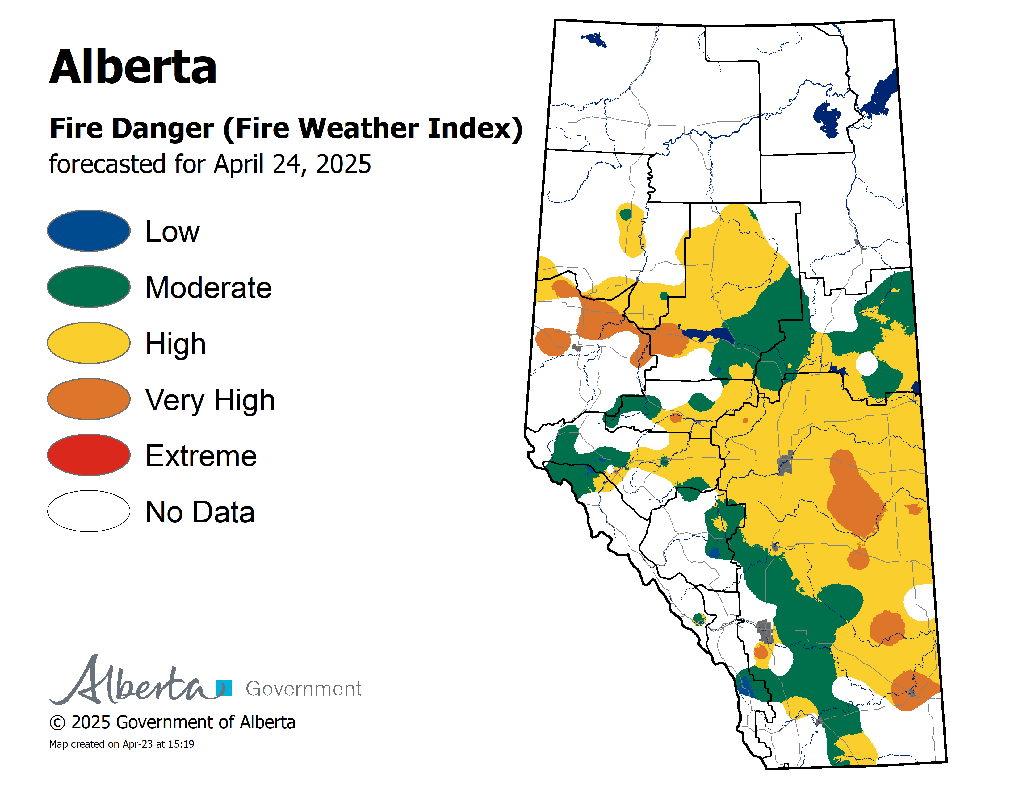
Wildfire Danger
The wildfire danger remains Extreme for areas north of Lesser Slave Lake, and Very High to High for areas south of Lesser Slave Lake.
Click here to view the wildfire danger map for Wednesday.
The Fire Ban and OHV Restriction remain in place for areas north of Lesser Slave Lake. To view a map and details regarding the Fire Ban/OHV restriction visit www.albertafirebans.ca
Smoky Conditions
Smoky conditions are expected to continue in the Wabasca area.
Click here to view the air quality statement that has been issued.
If you experience respiratory difficulties, visit Alberta Health Link or dial 811. Visit www.firesmoke.ca to view the most current smoke forecast.
Click here for Alberta Health Services Information about Wildfire Smoke.
Wildfire Update
Since the start of the wildfire season on March 1st, there have been 102 wildfires and 264,620 hectares burned in the Slave Lake Forest Area.
New Wildfire Starts
There were no new wildfire starts today.

Photo of SWF-102 taken June 11th at 6:18 pm.
SWF-102 is located 1.3 kilometres west of the Chip/Alpac Road at approximately kilometre 45. It started on June 9th. 23 firefighters, four helicopters and heavy equipment continue to fight this wildfire. It is 153 hectares in size and is classified as out of control.
Provincial Wildfire Situation
For information on the wildfire situation across the province of Alberta click here.
Click here to view a map of the wildfires burning in Alberta.
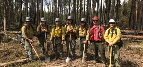
Photo of Logan Hotshot Firefighters from Utah working on the south side of the SWF049.
McMillan Wildfire Complex
Firefighters, heavy equipment and aircraft made excellent progress today fighting the McMillan Complex Wildfires. Of the five wildfires, two are under control and three are classified as out of control.
SWF-049 is 262,622 hectares and is classified as out of control.
SWF-078 is 137 hectares and is classified as under control.
SWF-079 is 993 hectares and is classified as out of control. This fire is located 9.4 kilometres to the northwest of Wabasca No. 166C.
SWF-090 is 215 hectares and is classified as out of control.
SWF-099 is 2 hectares and is classified as under control.
Yesterday the south end of SWF049 received between 2 millimeters to 8 millimeters of rain. Today, the north end of the fire received around 3 millimeters of rain.
SWF-049 is 30% contained as of June 10th.Excellent progress has been made on the east side of the fire, west of Bigstone Cree Nation and Wabasca. Firefighters remain in this area and are working to extinguish all fires well into the fire perimeter.
Today on SWF-049, firefighters were busy laying hose and soaking the fire within 30 metres of the fire guard on the south, east, west and north sides of the fire. Heavy equipment was busy building line on the south and west of the fire. Helipad construction continues on the north of the fire so crews can gain improved access to this area. Airtankers supported SWF-049 in areas on the west and south sides of the fire. Ignition operations are being used on the north side of the fire to bring the fire to secure boundaries. They were successful in reducing fire behavior so crews and heavy equipment could continue to build control lines. Firefighters are also patrolling for ground fires in the Marten Lakes Road area.
Firefighters continue to build line around SWF-079.
Great progress continues to be made on SWF- 078 and SWF-099 as all of these fires are under control.
There are 542 firefighters and support staff, 44 helicopters, airtankers, and 43 pieces of heavy equipment fighting this wildfire.
Structure protection remains in place for the communities of Trout Lake, Wabasca, Bigstone Cree Nation and Marten Beach.
Click here for a message from the Fire Chiefs of the Wabasca and Bigstone Cree Nation Fire Departments regarding the fire fighting equipment that has been left in place.
SWF049 remains approximately:
- 4.9 and 3.3 kilometres west of Wabasca No. 166B and 166D
- 26.5 kilometres northeast of Marten Beach
- 32.8 kilometres northeast of Slave Lake
- 9.3 kilometres southeast of Trout Lake
Click here to view a map with imagery and here for one without imagery of the McMillan Wildfire Complex.
An Alberta Wildfire Information booth is set up at the Calling Lake Evacuation Centre.
Re-entry for Bigstone Cree Nation and Municipal District of Opportunity No.17 hamlets of Sandy Lake, Wabasca- Desmarais and Chipewyan Lakes is planned for Wednesday June 12th.
For detailed and frequently updated information visit alberta.ca/emergency
View the June 11th afternoon update from the Municipal District of Opportunity No.17 Emergency Management facebook site.
View updates on highways by visiting 511.Alberta.ca or download the mobile app.
Alberta Emergency Alert and Road Closures as of June 11th - 8:00 pm
Alberta Transportation Road Closures
Highway 754 from Highway 88 to Wabasca is closed.Highway 813 from Wabasca to Sandy Lake is closed.
Stay informed on all road closures visit 511.Alberta.ca or download the mobile app.Weather
For Wednesday the temperature will be 24 to 26 degrees. Winds will be from the southwest/west 15-20 kilometres per hour. For areas north of Lesser Slave Lake there is a chance of thundershowers with lightning.

Leah Lovequist
Wildfire Information Officer
Mobile: 780-849-0945
Email:leah.lovequist@gov.ab.ca
Keep up to date on the wildfire situation by subscribing to the Slave Lake Forest Area Wildfire Update or download the free Alberta Wildfire app for Apple or Android devices.


