
Wildfire danger
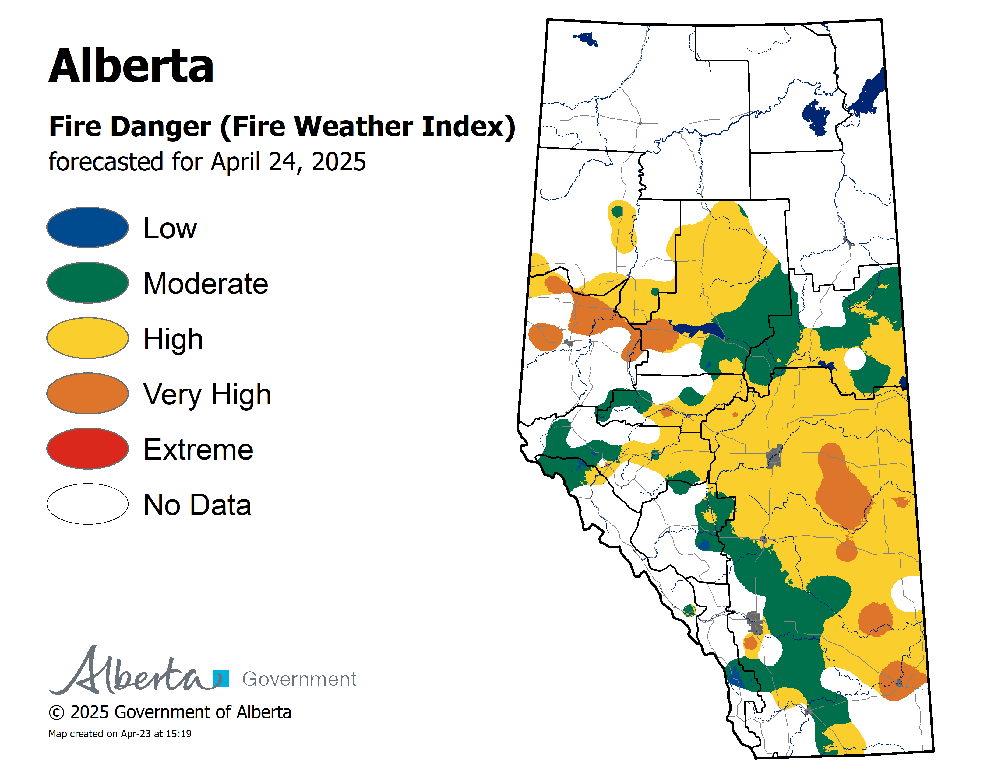
A small amount of rain was recorded for areas north of Lesser Slave Lake last night.The wildfire danger is HIgh to Very High for areas north of Lesser Slave Lake. Click here to view the wildfire danger map for today.Firefighters are urging everyone to use caution and report wildfires immediately by calling 310-FIRE or #FIRE on your cell phone.
Fire Ban/OHV Restriction has been adjusted as of 4:00 pm today.
The Fire Ban and OHV Restriction has been lifted for parts of the Slave Lake Forest Area. The Town of Slave Lake, Town of High Prairie and Big Lakes County have also lifted their Fire Ban/OHV Restriction.
Safe campfires are allowed. Never leave your campfire unattended and make sure it's extinguished. Soak it with water, Stir up the ashes and soak it again.When riding your off highway vehicle, stop frequently to remove the build up of debris from your muffler.
The northern portion of the Slave Lake Forest Area -areas north of Utikuma Lake, including Wabasca and to the north- remain under the Fire Ban and OHV Restriction.
To view a map of the Fire Ban/OHV restriction area visit www.albertafirebans.ca
To view a fact sheet on the OHV restriction click here.
To view a fact sheet on the fire ban click here.
Alberta Emergency Alert/Road Conditions
New Information Alerts have been issued for the Municipal District of Lesser Slave River No.124 and Town of Slave Lake.
For details visit www.emergencyalert.alberta.ca
For the most up to date information on road conditions visit www.511.alberta.ca
Wildfire Situation as of June 4th 12:30 pm
New Wildfire Starts
There was one new wildfire start last night. It is under control and firefighters are working to extinguish it.
Eight firefighters and three helicopters continue to fight SWF-093 which is located 11 kilometres south of Chipewyan Lakes. It is classified as being held and is 150 hectares.
Since the start of the wildfire season on March 1st, there have been 97 wildfires and 308,321 hectares burned in the Slave Lake Forest Area.
For information on the wildfire situation across the province of Alberta click here.
McMillan Wildfire Complex
The wildfire did receive a small amount of rain yesterday and firefighters reported a decrease in fire behavior. The wildfire did not experience growth.
For today firefighting efforts are focused on;
- Firefighters mopping up ignition lines on the southeast end of the fire along the power line this will strengthen control lines.
- Fire crews are extinguishing hot spots 100 feet in the fire perimeter on the Marten Lake Road.
- Heavy equipment continue to build fire guard south-west from the junction of Wabasca and Highway 754.
- Community protection continues to be established in Wabasca No. 166B and 166D.
- Community protection has been completed at Trout Lake and Marten Beach.
The wildfires are:
- 4.9 and 3.3 kilometres west of Wabasca No. 166B and 166D
- 26.5 kilometres northeast of Marten Beach
- 32.8 kilometres northeast of Slave Lake
- 9.3 kilometres southeast of Trout Lake
SWF-049 is 246,603 hectares and is classified as out of control.
SWF-078 is 137 hectares and is classified as out of control.
SWF-079 is 860 hectares and is classified as out of control.
SWF-090 is 187 hectares and is classified as out of control.
There are 347 firefighters and support staff, 35 helicopters and 35 pieces of heavy equipment fighting this wildfire.
Click here to view a map of the McMillan Wildfire Complex.
Click here to view a map of the wildfires burning in Alberta.
Alberta Wildfire Information booths are set up in the following location;
- Calling Lake Evacuation Centre
Weather
For Tuesday the temperature will be 16 degrees and winds will be from the southwest/west 20 kilometres per hour gusting up to 35. The forecast is calling for a chance of rain.
On high alert
Fire lookouts are on high alert constantly watching for smoke and firefighters in helicopters, various pieces of heavy equipment and airtankers are ready to respond to any new wildfires that may start.

FIRE BAN AND OFF-HIGHWAY VEHICLE RESTRICTION IN EFFECT
A fire ban and off-highway vehicle restriction is in effect for areas north of Utikuma Lake, including Wabasca and to the north.
To view a map of the fire ban/OHV restriction area visit www.albertafirebans.ca
To view a fact sheet on the OHV restriction click here.
To view a fact sheet on the fire ban click here.
Prohibited
If you have any questions please contact:
Leah Lovequist
Wildfire Information Officer
Mobile: 780-849-0945
Email:leah.lovequist@gov.ab.ca
Keep up to date on the wildfire situation by subscribing to the Slave Lake Forest Area Wildfire Update or download the free Alberta Wildfire app for Apple or Android devices.


