The wildfire hazard for the Peace River Wildfire Management Area is moderate with rain forecast for many parts of the area in the coming days.
Firefighters are taking advantage of the higher humidity levels and are making good progress on the ground with many wildfires burning in the area. Two new lightning wildfires started Friday and firefighters have one under control and the other contained. No new wildfires have started Saturday.

Thunderstorms are expected to continue. With thunderstorms comes an increased risk of lightning started wildfires. Please report wildfires by calling 310-FIRE (3473). Even though there has been some rain, the ground and trees are still dry.
In these conditions, wildfires can start easily. Please do your part and help us prevent wildfires.
PUT OUT YOUR CAMPFIRE
Dry conditions mean a wildfire can start easily and spread quickly. Do your part and make sure your campfire is fully extinguished. A campfire can burn deep into the ground and flare up again in dry or windy weather. Soak the ashes and stir them. Keep soaking the ashes until they are cool to the touch. Even if you are going for a short hike, make sure your campfire is out.
CHECK YOUR RIDE
Off-highway veichles can also start wildfires.While riding, stop frequently to check your vehicle for the build up of grass, branches or debris. This material can catch fire and drop from your vehicle as you drive; acting like a drip-torch it can start a wildfire. Learn more here.
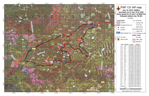
NOTIKEWIN COMPLEX MAP UPDATED JULY 11
Please continue to respect the restrictions to access that have been put in place for your safety and the safety of our fire fighters.
- PWF 129 is being held at 530 hectares in the Notikewin area (approximately 15 kms northwest of Sulphur lake). This wildfire has a fireguard complete around the whole perimetre
- PWF 131 has been mapped at 2926 hectares. This fire is located approximately 10 kms west of Sulphur Lake and 15 kms northwest of Stony Lake. Firefighters and airtankers worked to contain this wildfire. There was little growth on Saturday.
- *In order to ensure the safety of the public and our firefighters, access onto the Notikewin Tower Road, the Canfor Road, the DMI P2 200 and the Silver Creek Road will be limited to necessary personnel only until further notice. Please do NOT go into the area for any reason without first calling 780-618-6215.*
Local wildfires
There were two new wildfires today. Firefighters have contained them both. Here is a breakdown of the rest of the wildfires in the area:
- PWF 052 is under control at 1202.00 hectares in the Hotchkiss area.
- PWF 116 is under control at 5.40 hectares northeast of the Notikewin Provincial Park.
- PWF 130 is under control at 1.0 hectare in size in the Hawk Hills area.
- PWF 134 is under control at 0.5 hectares in size west of the Clearhills area.
- PWF 135 is being held at 6.0 hectares in size west of the Clearhills area.
- PWF 137 is being held at 3.4 hectares in size 16 km north of Hines Creek.
- PWF 138 is under control at 0.1 hectares in size 18 km north east of Kimiwan Lake
BC WILDFIRE

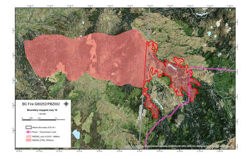
- PBZ002 - The wildfire located just on the BC side of the Alberta/British Columbia border in the Fontas area and approximately 2926 hectares of this fire are now burning within Alberta. There is a powerline in the burn area, but all of the poles are still standing.
Campfires
Safe campfires are permitted in campgrounds and back country or random camping areas.
Fire Permits
Fire permits are not suspended at this time, but may be in the future if the wildfire hazard continues to climb. Fire permits will be issued on a site-by-site basis and may be refused until conditions are more favorable.
Visit www.albertafirebans.ca for the latest fire ban information across the province.
Janelle Lane | Wildfire Information Officer
mobile: 780.217.1285


