

Chuckegg and Jackpot Creek Wildfires Remain Out of Control.
Fire Ban and Off-Highway Vehicle Restriction Continues.
HIGH LEVEL FOREST AREA | WILDFIRE UPDATE | JUNE 2, 2019 AT 11:00 A.M.
There are 2 active wildfires in the High Level Forest Area - both are Out of Control (OC).
- The Chuckegg Creek Wildfire (HWF-042) remains Out of Control (OC) at 279, 551hectares.
- The Jackpot Creek Wildfire (HWF-066) around Steen River remains Out of Control (OC) at 24,730 hectares. There are 68 firefighters and 9 helicopters working on the fire.
Click here for a map of all fire locations and statuses within the High Level Forest Area.
There are 142 wildland firefighters, 23 helicopters, 5 Airtankers and 8 pieces of heavy equipment positioned throughout the High Level Forest Area to action any new wildfire starts.

FIRE BAN AND OFF-HIGHWAY VEHICLE RESTRICTION REMAIN IN EFFECT
A Fire Ban and Off-Highway Vehicle Restriction is in effect for the High Level Forest Area due to warmer temperatures, gusty winds and no significant rain in the forecast. The ban and restriction will remain in effect until conditions improve. All fire permits are suspended and no new fire permits will be issued.
Prohibited
- All open fires including campfires in campgrounds, backcountry and random camping areas and backyard fire pits.
- Charcoal briquettes, turkey fryers and tiki torches.
- Fireworks and exploding targets.
- The use of off-highway vehicles for recreational use on all public lands.
Allowed
- Portable propane fire pits that are CSA approved or UL certified.
- Gas or propane stoves and barbecues that are CSA approved or UL certified and are designed for cooking or heating.
- Catalytic or infrared-style heaters.
Visit albertafirebans.ca for more information or download the new Alberta Fire Bans mobile app.
(Firefighters working on the south end of the Chuckegg Creek fire near Paddle Prairie)
THE CHUCKEGG CREEK FIRE | JUNE 02, 2019 AT 11:00 A.M.
Firefighters, heavy equipment, and aircraft continue to focus on establishing containment in priorities areas. Structural and wildland firefighters continue to work around Paddle Prairie to protect values. On the east side of the Peace River by Tompkins Landing, fire guard lines have been completed from the agricultural land to the Peace River with structural and municipal firefighters extinguishing hot spots along the fire perimeter to limit spread. Airtankers and bucketing helicopters are assisting ground operations as possible, but thick smoke continues to limit visibility on parts of the fire.
Firefighters continue to consolidate containment along Highways 35 and 58. Heavy equipment is building fire guards to the north of High Level to limit further spread of the fire towards Hutch Lake.
The forecast today anticipates dry conditions with winds prevailing from the west and southwest, with gusts up to 35 km/hour. A red flag weather watch has been issued, with the potential for extreme fire behaviour. Yesterday we saw scattered precipitation and thundershowers across parts of the fire, approximately 5-14mm. This in result can dampen fire activity and aid suppression efforts, but any return of warm and dry weather can revive fire behaviour.
- The last recorded size is approximately 279, 551 hectares.
- Firefighters utilized east winds yesterday to complete a successful burn-off by the Boyer Towers on the east side of the fire, tying the burn and fire perimeter to Highway 35. This burn-off will help protect the towers and limit the fire’s ability to progress further east at that point by eliminating available forest fuels.
- The Chuckegg Creek Fire experienced extreme fire behaviour on May 29th with significant growth to the south towards Paddle Prairie, across Highway 35 by Highway 697 and with spotting across to the east side of the Peace River. Continued hot and dry conditions along with variable, gusty winds have proved a challenge to firefighting efforts and safety.
- There have been no homes or businesses damaged to date around High Level, but the threat remains.
- The High Level Fire Department and other municipal firefighters have completed structural protection around High Level. In addition, structural protection has been completed on Mackenzie County homes southeast of High Level, Tolko and Norbord.
- Structural protection and firefighters are mobilized south of the fire by Paddle Prairie, to the east of the Peace River, and in the Keg River to Carcajou area.
- Alberta Wildfire has 385 firefighters, along with 130 structural firefighters. There are 41 helicopters.
- The significant fire run on May 29th damaged powerlines along Highway 35. Atco is currently working to assess damage. Atco has restored power supply and is supporting normal operations to the Town of High Level, La Crete, Fort Vermilion & Dene Tha’ First Nation. Atco has secured large-scale backup generators that can be drawn on to provide power to communities, if needed.
The next update will be at 08:00 P.M., or if conditions change.
Click here to view an updated Wildfire Status map.

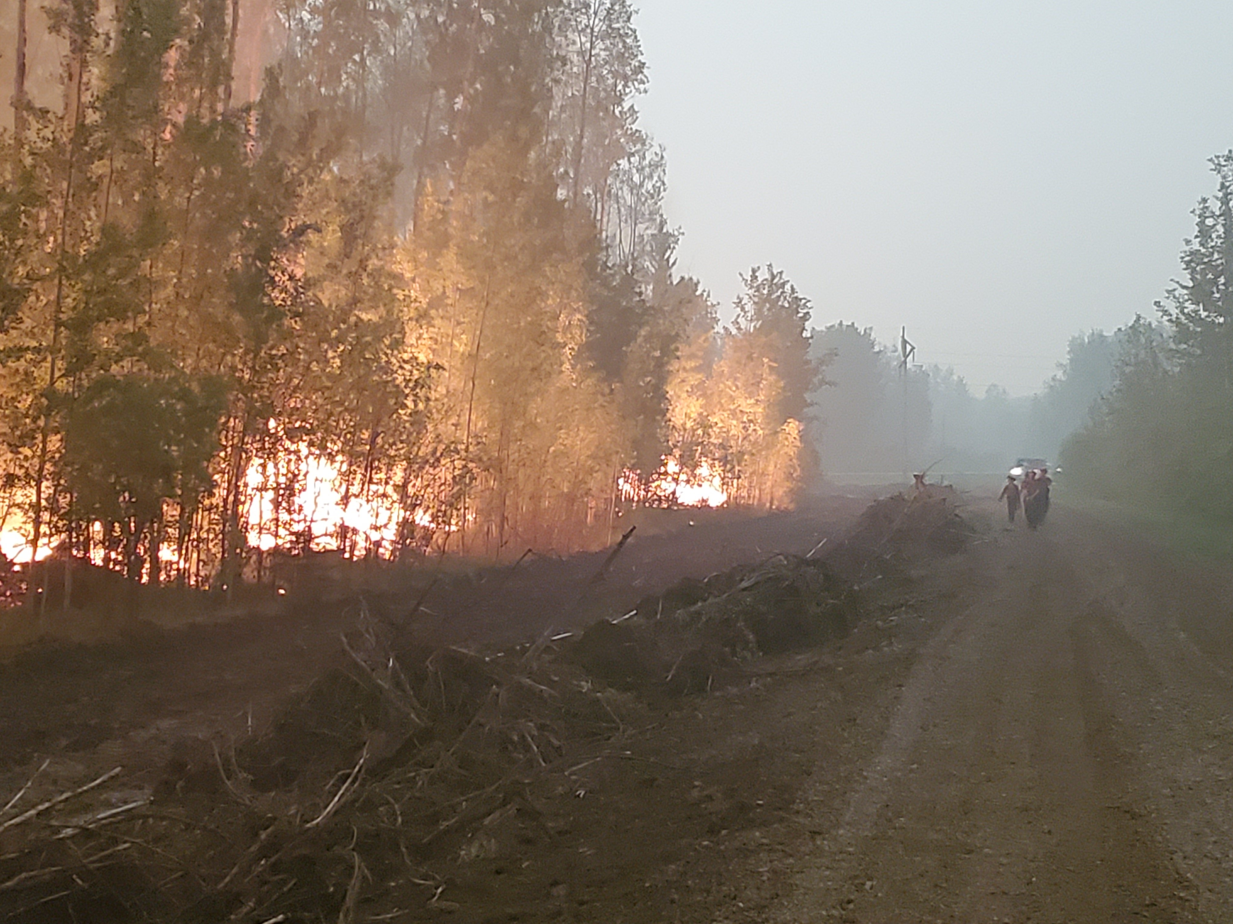
(Photo Taken June 1, 2019 Jackpot Creek fire)
THE JACKPOT CREEK FIRE | JUNE 2, 2019 AT 11:00 A.M.
Good progress was made by firefighters yesterday on the Jackpot Creek Fire. Lower temperatures, higher relative humidity levels and a limited amount of scattered precipitation helped crews with suppression efforts. Firefighters are working in strategic areas on the north section of the fire to help reduce smoke concerns for motorists on highway 35, a main access point to the Northwest Territories. Firefighters focused suppression efforts on the south side of the fire, using pumps and hose to work from the highway toward the east utilizing natural barriers as a fire guard. Firefighters are also building control lines towards the west on that southern section and will keep working along the fire’s edge to impede it’s spread. Suppression efforts will continue with the intent of reducing risk to both Zama City and the community of Meander as well as industrial values in the area.
Temperatures are expected to reach 18 degrees today with a relative humidity of 35%. Winds will be 25 km/h out of the west, southwest gusting up to 40 km/h. Some precipitation has been forecasted for the area today although confidence is low. There is still potential for significant fire behaviour with the forecasted winds.
- There has been some growth on the south flank over the last day or so, which will be reflected once the fire is remapped. The last recorded size was 24,730 hectares.
- There are 68 firefighters assigned to the incident as well as 9 helicopters and an Incident Management Team.
TOWN OF HIGH LEVEL | UPDATE
The Town of High Level has issued an Evacuation Order for the town as of May 20, 2019 at 4:00 p.m. For more info please continue to monitor the Town of High Level Website at www.highlevel.ca, call 780-926-2201 (Monitored from 8am-10pm) or visit Alberta Emergency Alert for more updates.
MACKENZIE COUNTY | UPDATE
An 8 hour evacuation alert has been issued for residents located in Mackenzie County east of High Level, in areas north and south of the Peace River, including La Crete, Fort Vermilion and Beaver First Nation’s Boyer River and Child Lake Reserves. The purpose of the evacuation alert is to allow for residents to prepare for a potential evacuation order.
The mandatory evacuation was issued for all residents located east of the La Crete Ferry campground, North and South of Highway 697 to Range Road 164 (Steep Hill Creek), the La Crete Ferry campground, the Mackenzie County rural residents south and southeast of the Town of High Level, the Town of High Level, and Steen River remains in effect.
The Mackenzie County Incident Command Centre is open at the Fort Vermilion County office (4511-46 Avenue) or call (780)927-3718. For all public notifications, please follow the Mackenzie County Facebook page.
NORTHERN LIGHTS COUNTY | UPDATE
The County of Northern Lights has declared a State of Local Emergency and has issued a Mandatory Evacuation Order for residents in the Keg River and Carcajou areas. All evacuees are requested to report at the Registration Centre located at the County of Northern Lights Main Office building at #600-7th Ave NW Manning. Please refer to the County of Northern Lights website for full details.
ALBERTA TRANSPORTATION
Alberta Transportation has closed Highway 35 south of High Level, Highway 58 west of High Level, and Highway 697 east of Highway 35 to the La Crete Ferry. The La Crete Ferry is also closed. To stay informed on all road closure info visit the Alberta Transportation website or download the mobile app.
SMOKE ISSUES
Smoke from wildfires in northern Alberta is causing poor air quality and reducing visibility. Winds will continue to shift bringing smoky conditions. Issued by Environment Canada, Alberta Environment and Parks, Alberta Health and Alberta Health Services.
Victoria Ostendorf
Wildfire Information Officer
Chuckegg Creek Fire
Mobile: 1-866-394-3473
Matthew Anderson
Wildfire Information Officer
High Level Forest Area
Mobile: 1-866-394-3473
RELATED INFORMATION