

The wildfire danger for the High Level Forest Area is Extreme. A Fire Ban and Off-Highway Vehicle Restriction remains in effect. Please use caution in the forested areas. To report a wildfire call 310-FIRE.
HIGH LEVEL FOREST AREA | WILDFIRE UPDATE | MAY 31, 2019
There are 2 active wildfires in the High Level Forest Area - both are Out of Control (OC).
- The Chuckegg Creek wildfire (HWF-042) remains Out of Control (OC) at 230,000 hectares.
- The Jackpot Creek Wildfire (HWF-066) around Steen River remains Out of Control (OC) at 24,730 hectares. There are 43 firefighters and 7 helicopters working on the fire.
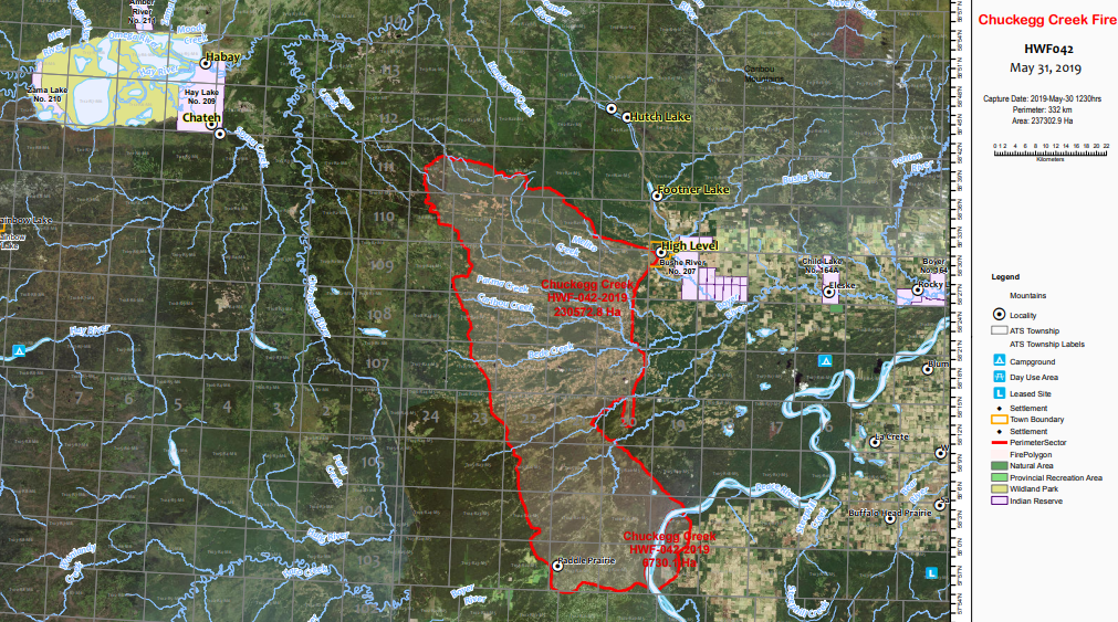
Click here for a map of all fire locations and statuses within the High Level Forest Area.
There are 142 wildland firefighters, 23 helicopters, 5 Airtankers and 8 pieces of heavy equipment positioned throughout the High Level Forest Area to action any new wildfire starts.

FIRE BAN AND OFF-HIGHWAY VEHICLE RESTRICTION REMAIN IN EFFECT
A Fire Ban and Off-Highway Vehicle Restriction is in effect for the High Level Forest Area due to warmer temperatures, gusty winds and no significant rain in the forecast. The ban and restriction will remain in effect until conditions improve. All fire permits are suspended and no new fire permits will be issued.
Prohibited
- All open fires including campfires in campgrounds, backcountry and random camping areas and backyard fire pits.
- Charcoal briquettes, turkey fryers and tiki torches.
- Fireworks and exploding targets.
- The use of off-highway vehicles for recreational use on all public lands.
Allowed
- Portable propane fire pits that are CSA approved or UL certified.
- Gas or propane stoves and barbecues that are CSA approved or UL certified and are designed for cooking or heating.
- Catalytic or infrared-style heaters.
Visit albertafirebans.ca for more information or download the new Alberta Fire Bans mobile app.
%20-%20Copy.jpg?width=4032&name=20190529%20Chuckegg%20Fire%20(South)%20-%20Copy.jpg)
(Chuckegg Creek Fire - taken May 29, 2019 as the fire moved south in extreme conditions)
THE CHUCKEGG CREEK FIRE | MAY 31, 2019 AT 11:00 A.M.
Firefighters, heavy equipment, and aircraft are focusing on establishing containment in priorities areas, including: north of Highway 58, from Highway 35 to the Peace River, the Paddle Prairie area, and to the east of the Peace River. Structural firefighters continue to assess and mobilize structural protection in critical areas of the fire, with focus in and around Paddle Prairie where active fire remains, as well as east of the Peace River and from Keg River to Carcajou to the south of the fire.
Firefighters continue to consolidate containment along Highway 35 to High Level. Heavy equipment is building fire guards to the north of High Level to limit further spread of the fire on the north side towards Hutch Lake. Thick smoke continues to prove a challenge to the safe ability of personnel and aircraft to operate south of Paddle Prairie. The weather outlook expects winds from the east today, with continued warm and dry conditions and limited levels of the substantial precipitation needed to significantly calm fire behaviour and aid firefighters in suppression efforts.
- The last recorded size is approximately 237,000 hectares. The change in fire size from 230,000 to 237,000 is due to more accurate mapping over the last few days, and is not indicative of growth yesterday.
- The Chuckegg Creek Fire experienced extreme fire behaviour on May 29th with significant growth to the south towards Paddle Prairie, across Highway 35 by Highway 697 and with spotting across to the east side of the Peace River. Continued hot and dry conditions along with variable, gusty winds have proved a challenge to firefighting efforts and safety.
- Alberta Wildfire firefighters in conjunction with municipal firefighters, along with air support from helicopters and airtankers continue to work hard to contain the fire. There have been no homes or businesses damaged to date around High Level, but the threat remains.
- The High Level Fire Department and other municipal firefighters have set up sprinklers on the southwest and northwest side of town. In addition, structural protection has been completed on Mackenzie County homes southeast of High Level, Tolko and Norbord. Structural protection and firefighters have been mobilized south of the fire by Paddle Prairie, to the east of the Peace River, and in the Keg River to Carcajou area.
- 130 structural firefighters that continue to establish and maintain structural protection on homes in the Town of High Level and on other critical values at risk within Mackenzie County. Alberta Wildfire has 400 firefighters and 26 helicopters on this fire.
- The significant fire run on May 29th damaged powerlines along Highway 35, Atco is working to assess damage. Atco has restored power supply and is supporting normal operations to Mackenzie County, Town of High Level, La Crete, Fort Vermilion & Dene Tha’ First Nation. Atco has secured large-scale backup generators that can be drawn on to provide power to communities, if needed.
The next update will be at 08:00 PM, or if conditions change.
TOWN OF HIGH LEVEL | UPDATE
The Town of High Level has issued an Evacuation Order for the town as of May 20, 2019 at 4:00 p.m. For more info please continue to monitor the Town of High Level Website at www.highlevel.ca, call 780-926-2201 (Monitored from 8am-10pm) or visit Alberta Emergency Alert for more updates.
MACKENZIE COUNTY | UPDATE
The mandatory evacuation for the La Crete Ferry campground, North and South of Highway 697 to Range Road 164 (Steep Hill Creek), the Mackenzie County rural residents south and southeast of the Town of High Level, the Town of High Level, and Steen River remains in effect.
The Mackenzie County Incident Command Centre is open at the Fort Vermilion County office (4511-46 Avenue) and the phone number for inquiries is (780) 927-3718 (monitored 24/7). For all public notifications, please follow the Mackenzie County Facebook page.
NORTHERN LIGHTS COUNTY | UPDATE
The County of Northern Lights has declared a State of Local Emergency and has issued a Mandatory Evacuation Order for residents in the Keg River and Carcajou areas. All evacuees are requested to report at the Registration Centre located at the County of Northern Lights Main Office building at #600-7th Ave NW Manning. Please refer to the County of Northern Lights website for full details.
ALBERTA TRANSPORTATION
Alberta Transportation has closed Highway 35 south of High Level, Highway 58 west of High Level, and Highway 697 east of Highway 35 to the La Crete Ferry. The La Crete Ferry is also closed. To stay informed on all road closure info visit the Alberta Transportation website or download the mobile app.
SMOKE ISSUES
Smoke from wildfires in northern Alberta is causing poor air quality and reducing visibility. Winds will continue to shift bringing smoky conditions. Issued by Environment Canada, Alberta Environment and Parks, Alberta Health and Alberta Health Services.
Claire Allen
Wildfire Information Officer
Chuckegg Creek Fire
Mobile: 1-866-394-3473
Matthew Anderson
Wildfire Information Officer
High Level Forest Area
Mobile: 1-866-394-3473
RELATED INFORMATION