

A Fire Advisory remains in effect for the High Level Forest Area:
Use caution within the Forest Protection Area. To report a wildfire, call 310-FIRE (3473). The Jackpot Creek fire is Under Control (UC).
HIGH LEVEL FOREST AREA UPDATE | JULY 13, 2019 AT 7:00 P.M.
There are currently 4 active wildfires in the High Level Area. Of these fires, 1 is Out of Control (OC), and 3 are Under Control (UC). (See below for details on the Chuckegg Creek wildfire). Click here for a map of all fire locations and their status within the High Level Forest Area.
NOTE: The next update will be by 11:00 a.m., or if conditions warrant.
Firefighters, helicopters, airtankers and heavy equipment are positioned throughout the High Level Forest Area to respond to any new wildfire starts.

(Pictured above is one of the large water reservoirs helping firefighters get water to the fireline on the east side as water access has been challenging. These tanks can hold 750,000 gallons and are helping firefighters directly attack the fire perimeter and are also supplying water to the sprinkler system helping to flood the areas where the fire is burning very deep in peat moss.)
CHUCKEGG CREEK WILDFIRE UPDATE | JULY 13, 2019 AT 7:00 P.M.
The fire saw minimal activity today as cooler temperatures and higher humidity levels helped freighters make great progress in all priority areas. The fire in the area south of Surette Lake that spotted across the heavy equipment guard and old telegraph line is contained, as heavy equipment completed a fireguard around the area that had spread. Smoky conditions were experienced today as winds pushed smoke into the Town of High Level and surrounding areas due to the south/southeast winds.
On the east side of the fire, west of La Crete, the fire continue to burn in very deep areas of peat moss, which continues to create some challenges for firefighters. Firefighters along with heavy equipment continue to make progress in establishing guard in this area using the large water delivery system. Firefighters and personnel have established large pumps, water tanks, a large water reservoir and sprinklers on the east side of the fire. This system is being utilized for sprinkler operations that will be running 24/7 to help flood the area where the fire is burning in deep peat moss. This system will also aid firefighters with direct attack on the fire perimeter. Helicopters and airtankers also continue to support firefighting efforts by dropping retardant and water on the fire perimeter in priority areas to limit fire spread.
Progress continues to be made by firefighters on the west, south, and southeast side. As firefighters, continue with direct attack extinguishing hotspots and mopping-up 100 feet inward, south of Highway 58. In the southwest, hose lay, mop-up and extinguishing hotspots is ongoing. In the southern end of the wildfire, infrared scanning continues to aid firefighters in finding hotspots and they continue to extinguish hotspots in priority areas.
- The last recorded size is 334,013 hectares.
- There are 1,229 firefighters and support staff, 46 helicopters and 123 pieces of heavy equipment fighting this wildfire.
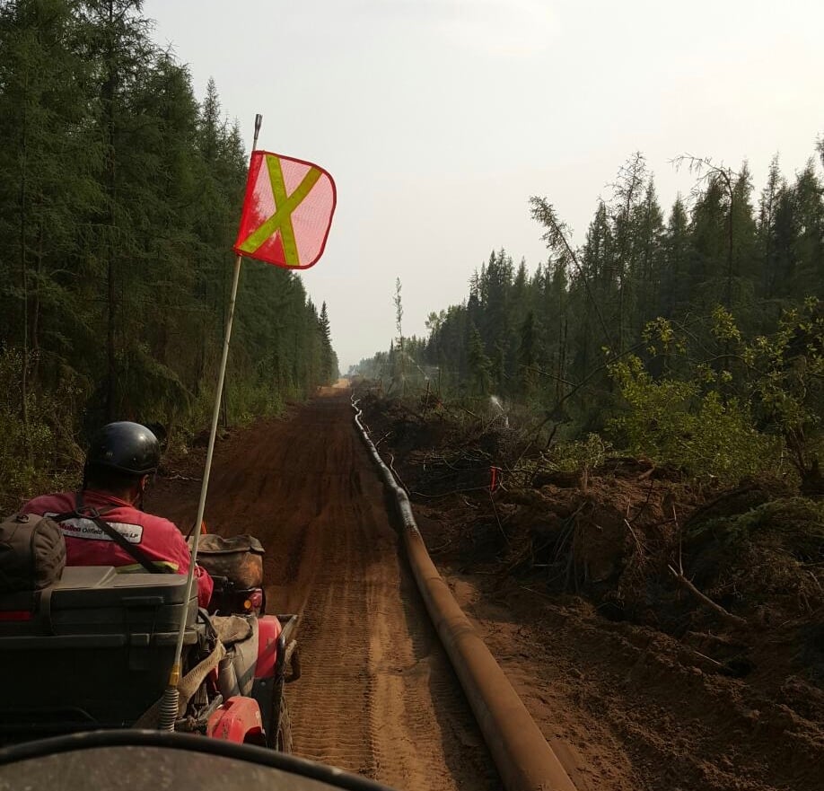
(Pictured above is a big 12" hose carrying water from the large water reservoir to firefighters and is supply water to the sprinkler system, seen here on the right hand side of the fireguard created by heavy equipment.)


FIRE ADVISORY IN EFFECT FOR THE HIGH LEVEL FOREST AREA
A Fire Advisory remains in effect due to ongoing wildfire activity within the High Level Forest Area.
- Safe Campfires are currently allowed
- Current seasonal permits issued until October 31, 2019 remain valid
- New permits will only be issued for:
- smudges
- burn barrels
- light yard debris
- root piles/rows
To get a fire permit please call 780-926-5407 and leave a detailed message including your home address, burn location and what you plan to burn. A patrolman will contact you to arrange a site visit.
Visit albertafirebans.ca for more information or download the new Alberta Fire Bans mobile app.
ALERTS AND EVACUATIONS | BE PREPARED, STAY INFORMED
Download the Alberta Emergency Alert App or visit their website by Clicking Here. You can also check with the County, the Town or your local community to see if new alerts or evacuation orders have been issued.
ROAD CLOSURE INFORMATION
To stay informed on all road closure info visit the Alberta Transportation website or download the mobile app.
SMOKE ISSUES
Smoke from wildfires in northern Alberta has caused poor air quality and reducing visibility at times. Winds will continue to shift bringing smoky conditions. For health related smoke issues, please visit Alberta Health Services.
PUBLIC SAFETY - WILDFIRE OPERATIONS
During an active wildfire, the highest priority is the safety of the public and wildfire personnel. Please refrain from entering areas of active wildfire suppression. If you encounter aircraft or helicopter bucketing operations on a water body please move your boat to shore.
The airspace around a wildfire is restricted via NOTAM in a radius of 9 kilometres to an altitude of 3,000 feet above ground level. It is illegal to operate any aircraft not associated with wildfire suppression within the restricted area, including drones. Do not fly drones or UAVs near or within the perimeter of an active wildfire. When a drone is near a wildfire it endangers firefighting personnel and important aerial firefighting operations will be grounded. Those caught in violation can be subject to an automatic court appearance and a fine of up to $100,000.

Victoria Ostendorf | Wildfire Information Officer
High Level Forest Area
Phone: 780-841-9387
1-866-FYI-FIRE
RELATED INFORMATION