

A Fire Advisory remains in effect for the High Level Forest Area.
Use caution within the Forest Protection Area. To report a wildfire, call 310-FIRE (3473). The Jackpot Creek fire is Under Control (UC).
HIGH LEVEL FOREST AREA UPDATE | JULY 18, 2019 AT 7:00 P.M.
There are currently 9 active wildfires in the High Level Area. Of these fires, 4 are Out of Control (OC), 2 are Being Held (BH) and 3 are Under Control (UC).
(See below for details on the Chuckegg Creek wildfire). Click here for a map of all fire locations and their status within the High Level Forest Area.
Wildfires of note:
- Fire (HWF127) is located 26 km west of Garden River and is classified as Out of Control (OC) at 8 hectares. There are 4 firefighters and 1 helicopters working on this fire. There is no threat to any communities at this time.
- Fire (HWF126) is located 20 km northwest of Zama City and is classified as Out of Control (OC) at 45 hectares. There are 10 firefighters, 2 helicopters, airtankers and heavy equipment working on this fire. There is no threat to any communities at this time.
- Fire (HWF-124) is located 10 km southeast of High Level and is Under Control (UC) at 4 hectares. There are 21 firefighters and 2 helicopters working on this fire. There is no risk to communities at this time.
- Fire (HWF-117) is located approximately 8 km to the southwest of the community of Chateh and is Extinguished (EX) at 1.5 hectares. There are no resources working on this fire.
- Fire (HWF-113) is located 62 km southeast of the Town of Rainbow Lake and is Out of Control (OC) at 132 hectares. There are 41 firefighters with the support of airtankers working on this fire. There is no risk to communities at this time.
- The Jackpot Creek wildfire (HWF-066) is located north of Lutose and is Under Control (UC) at 74,331 hectares. There are 32 firefighters and 9 helicopters and 4 pieces of heavy equipment working on this fire.
NOTE: Unless conditions change, the next update will be at 11:00 a.m. on July 19, 2019.
Firefighters, helicopters, airtankers and heavy equipment are positioned throughout the High Level Forest Area to respond to any new wildfire starts.
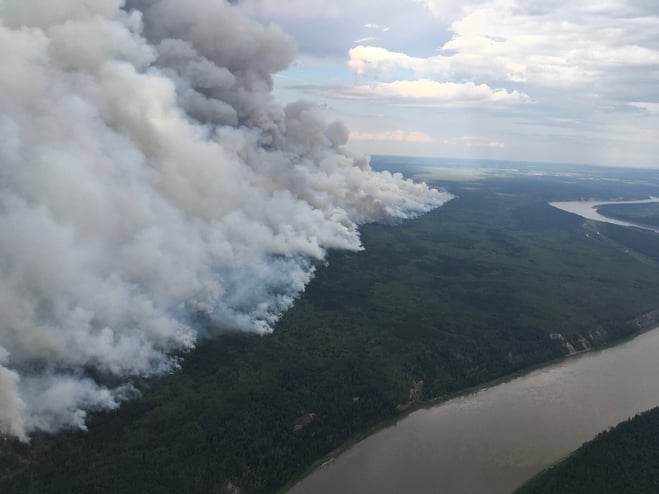
Fire activity during the ignition burn along the west side of the Peace River - Chuckegg Creek (July 17, 2019)
CHUCKEGG CREEK WILDFIRE UPDATE | JULY 18, 2019 AT 7:00 P.M.
Please be advised: smoke will continue to persist over surrounding communities. If you have any health concerns, please contact Alberta Health Services for assistance.
Fire activity remained quieter today as smoke coverage and weather over the eastern portion made visibility difficult for firefighters and helicopters to maintain consistent suppression efforts. Two fingers of the fire south and southwest of Devil Lake are making their way towards the fireguard but are expected to lose momentum as it nears closer to swampy land.
The planned ignition burn started later than scheduled today in the horseshoe west of the Peace River, but was postponed shortly after as conditions and visibility were unfavourable. Ignition specialists are developing a new plan and will look to continue operations when conditions are favourable again.
Firefighters on the ground continue to work the perimeter northeast of the Boyer River Cell Tower with support from helicopters where necessary, establishing containment line and tying it into the fireguard.
Extreme fire behaviour potential is expected for tomorrow as crossover conditions are likely to occur, meaning the temperature will be higher than the relative humidity in the air. Temperatures should reach 28 degrees with a relative humidity of 20-25%. Winds will be from the north/northwest at 10 km/hr., therefore communities south/southeast of the fire may experience an increase in smoke.
-----
Did you know?
Strategic ignition burning has many benefits to firefighting efforts. Burning off sections near a fire's perimeter reduces the strength a wildfire can develop if exposed to the right fuel type, helping containment efforts for firefighters on the ground.
-----
Although the ignition burn is taking place near the water delivery system on the eastern side, it's still proving to be a very effective tool in limiting spread along the southern portion of the horseshoe. Large pumps, water tanks, a large water reservoir and sprinklers are being utilized for sprinkler operations and will be running 24/7 to help flood the area where the fire is burning in deep peat moss. Having this operation in place will continue to aid firefighters with direct attack on the fire perimeter. Heavy equipment and helicopters also continue to support firefighting efforts where needed.
Fire activity is ongoing within the perimeter of the fire, however all of the containment lines on the west, south, and southeast sides continue to be holding well. Firefighters are working hard with direct attack, extinguishing hotspots and mopping-up 100 feet inward south of Highway 58. Hose lay, mop-up and extinguishing hotspots continues on the southwest side, as firefighters are making great progress securing that side. In the southern end, high-altitude scanning continues to aid firefighters in finding priority area hotspots to address and extinguish.
The Chuckegg Creek wildfire will continue to be an active wildfire situation. As a result, smoke may be present along nearby highways and communities. Please use caution as you travel through these areas to ensure the safety of firefighters and community residents.
- The last recorded size is 338,648 hectares.
- There are 921 firefighters and support staff, 48 helicopters and 125 pieces of heavy equipment fighting this wildfire.


FIRE ADVISORY REMAINS IN EFFECT FOR THE HIGH LEVEL FOREST AREA
A Fire Advisory remains in effect due to the hotter temperatures, no significant rainfall and the ongoing wildfire activity within the High Level Forest Area.
Current short term permits will not be renewed and all permit holders with root rows/root piles need to ensure all piles are extinguished prior to the expiry of their permit.
- Safe Campfires are currently allowed
- Current seasonal permits issued until October 31, 2019 remain valid
- New permits will only be issued for:
- smudges
- burn barrels
To get a fire permit please call 780-926-5407 and leave a detailed message including your home address, burn location and what you plan to burn. A patrolman will contact you to arrange a site visit.
Visit albertafirebans.ca for more information or download the new Alberta Fire Bans mobile app.
ALERTS AND EVACUATIONS | BE PREPARED, STAY INFORMED
Download the Alberta Emergency Alert app or visit their website by clicking here. You can also check with the county, the town or your local community to see if new alerts or evacuation orders have been issued.
ROAD CLOSURE INFORMATION
To stay informed on all road closure information visit the Alberta Transportation website or download the mobile app.
SMOKE ISSUES
Smoke from wildfires in northern Alberta has caused poor air quality and reducing visibility at times. Winds will continue to shift bringing smoky conditions. For health related smoke issues, please visit Alberta Health Services.
PUBLIC SAFETY - WILDFIRE OPERATIONS
During an active wildfire, the highest priority is the safety of the public and wildfire personnel. Please refrain from entering areas of active wildfire suppression. If you encounter aircraft or helicopter bucketing operations on a water body please move your boat to shore.
The airspace around a wildfire is restricted via NOTAM in a radius of 9 kilometres to an altitude of 3,000 feet above ground level. It is illegal to operate any aircraft not associated with wildfire suppression within the restricted area, including drones. Do not fly drones or UAVs near or within the perimeter of an active wildfire. When a drone is near a wildfire it endangers firefighting personnel and important aerial firefighting operations will be grounded. Those caught in violation can be subject to an automatic court appearance and a fine of up to $100,000.

Kevin Kuhn | Wildfire Information Officer
High Level Forest Area
Phone: 780-843-5846
1-866-FYI-FIRE
k.kuhn@mistikenvironmental.com
Matt Bell | Wildfire Information Officer (Chuckegg Creek wildfire)
Phone: 587-986-4985
1-866-FYI-FIRE
RELATED INFORMATION