

CHUCKEGG CREEK WILDFIRE UPDATE | JULY 17, 2019 AT 1:00 P.M.
Pending the right conditions, a controlled ignition operation is expected today and over the next several days for the area highlighted in pink, within the horseshoe west of the Peace River.
Protecting human life and communities are top priorities. Conducting this operation will help to reduce the potential for the wildfire to grow further, limiting the risk to MacKenzie County and surrounding communities. Residents in that area will likely see a dramatic increase in smoke as a result.
For health issues related to smoke, please contact Alberta Health Services.

HIGH LEVEL FOREST AREA UPDATE | JULY 17, 2019 AT 11:30 A.M.
There are currently 11 active wildfires in the High Level Area. Of these fires, 2 are Out of Control (OC), 4 are Being Held (BH) and 5 are Under Control (UC). (See below for details on the Chuckegg Creek wildfire). Click here for a map of all fire locations and their status within the High Level Forest Area.
wildfires of note:
- Fire (HWF113) is located 62 km southeast of the Town of Rainbow Lake and is Out of Control (OC) at 131 hectares. There are 9 firefighters with the support of airtankers and helicopters working on this fire.
- Fire (HWF117) is located approximately 8 km to the southwest of the community of Chateh and is Under Control (UC) at 1.5 hectares. There are 10 firefighters and 2 helicopters working on this fire.
NOTE: Unless conditions change, the next update will be at 7:00 p.m. on July 17, 2019.
Firefighters, helicopters, airtankers and heavy equipment are positioned throughout the High Level Forest Area to respond to any new wildfire starts.
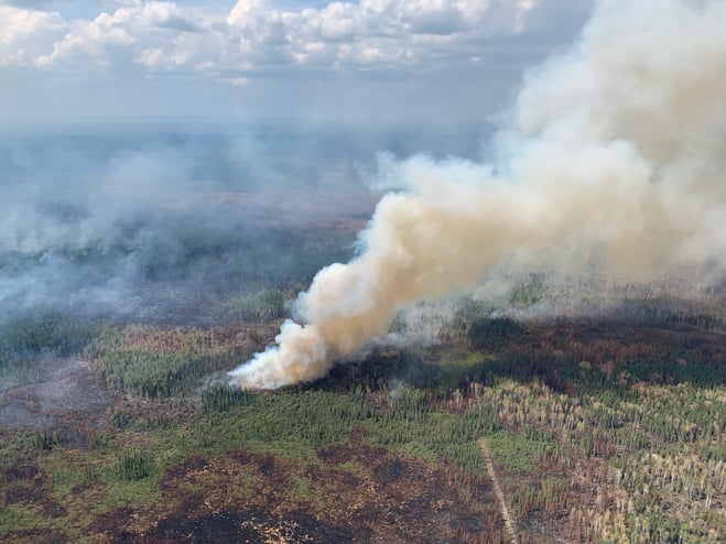
Fire activity within the perimeter - Chuckegg Creek (July 16, 2019)
CHUCKEGG CREEK WILDFIRE UPDATE | JULY 17, 2019 AT 11:30 A.M.
No significant updates to report from last night, however further fire activity is expected for most of today as weather conditions will be similar to what we have seen over the last 48 hours. Temperatures are expected to reach 25 degrees with a relative humidity of 40%, with winds coming from the southeast at 15 km/hr.
The Chuckegg Creek wildfire will continue to be an active wildfire situation. As a result, smoke may be present along nearby highways and communities. Please use caution as you travel through these areas to ensure the safety of firefighters and community residents.
Yesterday presented some difficulties for firefighters as portions of the perimeter challenged the fireguard along the east side, approximately 28 km south/southeast of High Level. Spot fires were identified approximately 3.5 km south/southwest of Surette Lake and 11 km north/northwest of Moose Island, but were quickly responded to by firefighters, helicopters and airtankers. Fire growth also occurred northeast of the Boyer River Tower area east of Highway 35. Today’s increased activity poses no new threat to nearby communities at this time.
Did you know?
Fire is a natural occurrence within our ecosystem. Fire growth within a wildfire perimeter may continue to be active, however it’s may not threaten additional values and may be important to allow more natural regeneration of the forest.
Firefighters and heavy equipment continue to make progress in establishing guard along the eastern portion of the fire using a large water delivery system that features large pumps, water tanks, a large water reservoir and sprinklers. This system is being utilized for sprinkler operations that will be running 24/7 to help flood the area where the fire is burning in deep peat moss. Having this operation in place will continue to aid firefighters with direct attack on the fire perimeter. Heavy equipment and helicopters also continue to support firefighting efforts where needed.
Fire activity is ongoing within the perimeter of the fire, however all of the containment lines on the west, south, and southeast sides continue to be holding well. Firefighters continue to work hard with direct attack extinguishing hotspots and mopping-up 100 feet inward south of Highway 58. In the southwest, hose lay, mop-up and extinguishing hotspots is ongoing. In the southern end, high-altitude scanning continues to aid firefighters in finding priority areas to address and extinguish.
- The last recorded size is 334,481 hectares.
- There are 978 firefighters and support staff, 48 helicopters and 83 pieces of heavy equipment fighting this wildfire.

FIRE ADVISORY REMAINS IN EFFECT FOR THE HIGH LEVEL FOREST AREA
A Fire Advisory remains in effect due to the hotter temperatures, no significant rainfall and the ongoing wildfire activity within the High Level Forest Area.
Current short term permits will not be renewed and all permit holders with root rows/root piles need to ensure all piles are extinguished prior to the expiry of their permit.
- Safe Campfires are currently allowed
- Current seasonal permits issued until October 31, 2019 remain valid
- New permits will only be issued for:
- smudges
- burn barrels
To get a fire permit please call 780-926-5407 and leave a detailed message including your home address, burn location and what you plan to burn. A patrolman will contact you to arrange a site visit.
Visit albertafirebans.ca for more information or download the new Alberta Fire Bans mobile app.
ALERTS AND EVACUATIONS | BE PREPARED, STAY INFORMED
Download the Alberta Emergency Alert app or visit their website by clicking here. You can also check with the county, the town or your local community to see if new alerts or evacuation orders have been issued.
ROAD CLOSURE INFORMATION
To stay informed on all road closure information visit the Alberta Transportation website or download the mobile app.
SMOKE ISSUES
Smoke from wildfires in northern Alberta has caused poor air quality and reducing visibility at times. Winds will continue to shift bringing smoky conditions. For health related smoke issues, please visit Alberta Health Services.
PUBLIC SAFETY - WILDFIRE OPERATIONS
During an active wildfire, the highest priority is the safety of the public and wildfire personnel. Please refrain from entering areas of active wildfire suppression. If you encounter aircraft or helicopter bucketing operations on a water body please move your boat to shore.
The airspace around a wildfire is restricted via NOTAM in a radius of 9 kilometres to an altitude of 3,000 feet above ground level. It is illegal to operate any aircraft not associated with wildfire suppression within the restricted area, including drones. Do not fly drones or UAVs near or within the perimeter of an active wildfire. When a drone is near a wildfire it endangers firefighting personnel and important aerial firefighting operations will be grounded. Those caught in violation can be subject to an automatic court appearance and a fine of up to $100,000.

Victoria Ostendorf | Wildfire Information Officer
High Level Forest Area
Phone: 780-841-9387
1-866-FYI-FIRE
Matt Bell | Wildfire Information Officer (Chuckegg Creek wildfire)
Phone: 587-986-4985
1-866-FYI-FIRE
RELATED INFORMATION