

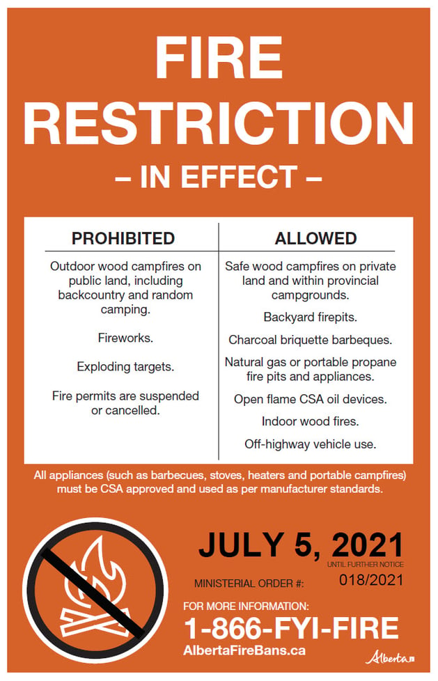
A fire restriction remains in effect for the Edson Forest Area.
Please be cautious when working or recreating in the outdoors. Be mindful of hot exhaust, spark or friction. Keep watch of your surroundings and ensure your activities or equipment do not cause a wildfire.
If you see smoke or flame and suspect it's a wildfire, call 310-FIRE.
Airtankers made great progress on EWF123 which is now BEING HELD (July 15, 2021 at 1:30 p.m)
EDSON FOREST AREA FIRE DANGER RATING
The wildfire danger in the Edson Forest Area is EXTREME.
NEW WILDFIRE DETECTIONS
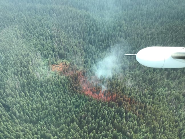
EWF123 is now BEING HELD which means that given current weather conditions and resources, the wildfire is not anticipated to grow past expected boundaries. The wildfire is located 7 km south of Hinton and 8 km east of Seabolt Estates. It was detected today at 10:45 a.m and has been reassessed at 0.3 ha in size.
Six airtankers have completed drops of retardant and two helicopters will continue with bucket operations. There are 13 firefighters on scene working to contain the wildfire.
We ask that the public stay clear of the bodies of water being used for bucket operations. We also ask the public to stay off the Bighorn Trail Bike system until further notice as firefighters are using the trails to access the wildfire.
There is no threat to any communities at this time however we ask residents to stay vigilant. The cause of this wildfire is under investigation.
EWF124 is classified as BEING HELD 40 km south of Grande Cache on the border of Jasper National Park within the same burnt area of the 2015 Rock Slide wildfire. The fire is currently estimated to be 7.8 ha in size. Firefighters are assessing the wildfire.
EWF125 is burning OUT OF CONTROL 26 km south west of Grande Cache. The fire is currently estimated to be 0.1 ha in size. Firefighters are assessing the wildfire and one helicopter will be actioning the fire.
To view the wildfire on a map, download the new AB Wildfire Status App.
To understand what the wildfire classifications mean, visit our website by clicking here.
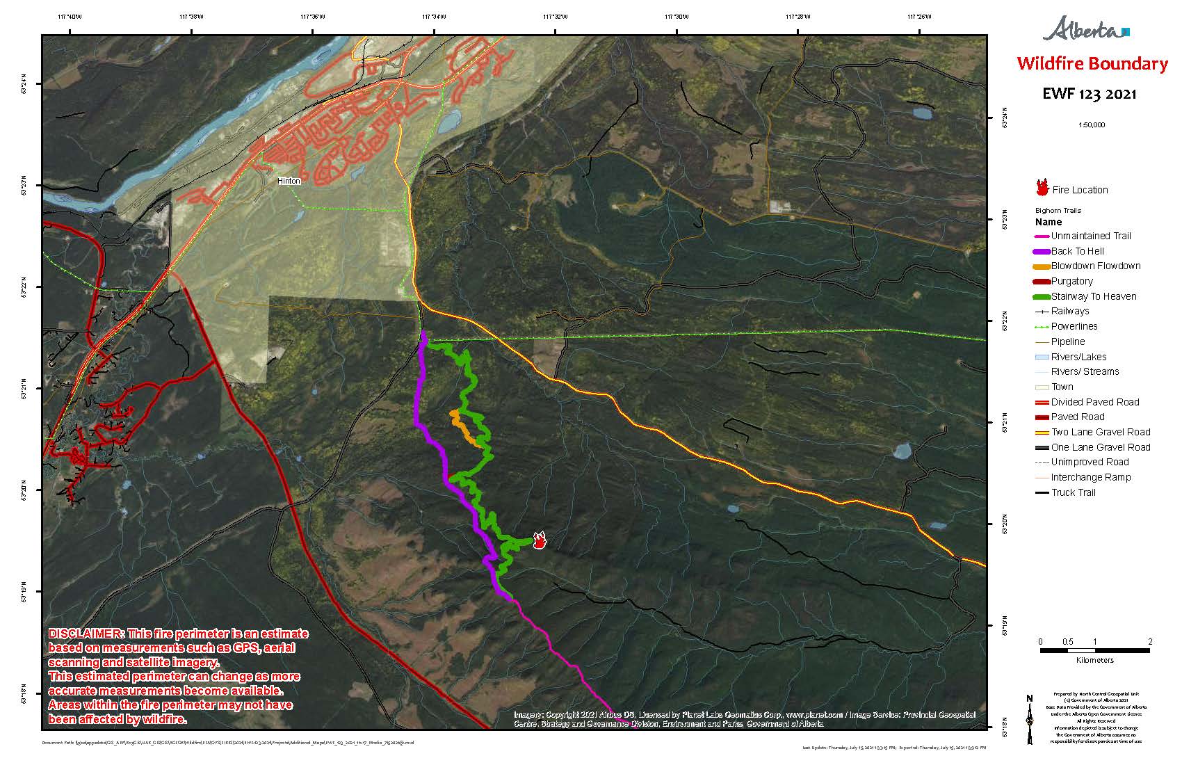
Map showing EWF123 8 km east of Hinton within the Bighorn Trail System (July 15, 2021 at 1:30 p.m)
SMOKE CONCERNS
Wildfire smoke may be affecting residents in our forest area. The smoke over our area is not produced by any current wildfires in Alberta. For those of you wondering what location the smoke is coming from, visit FireSmoke.ca. The service can produce forecasts of hourly ground-level concentrations of smoke from wildfires up to 48 hours in advance.
If you have smoke-related health concerns, please contact Alberta 811 or visit their website by clicking here.
EDSON FOREST AREA WILDFIRE UPDATE
Since March 1, 2021, there have been 122 wildfires in the Edson Forest Area burning a total of 820 ha. To date, 74% of the wildfires in our forest area have been human-caused and could have been prevented.
EWF108 is now UNDER CONTROL. The fire is located 33 km north west of Edson, 2 km south of the Emerson (A) Road and 16 km west of the Amoco/North Road. The fire was reassessed and is 6 ha in size. The cause of the wildfire was determined to be lightning.
EWF093 and EWF094 are both located 12 km north of Cynthia and 73 km south east of Edson on the east side of highway 753. The fires are 2.5 km from each other. EWF094 remains UNDER CONTROL and is 1.5 ha in size. EWF093 is also UNDER CONTROL and is 43 ha in size. There are 10 firefighters and one helicopter assigned to this wildfire. The cause of these wildfires was determined to be lightning.
EWF075 was detected on June 22 and is UNDER CONTROL. The wildfire is located 9 km west of Evansburg, north of highway 16 and west of highway 22. The wildfire is 175 hectares in size. No new growth has been reported since the evening of June 22. They will remain vigilant until the wildfire is fully extinguished. The cause of the wildfire is currently under investigation.
EWF036 was detected on April 30 and is estimated to be 479 ha in size. The wildfire remains classified as UNDER CONTROL and is located 20 km south of Carrot Creek, 25 km north west of Cynthia and 45 km south east of Edson. Crews will continue to monitor for hotspots until it is determined to be fully extinguished. The cause of the wildfire are currently under investigation.
To view the wildfires on a map, download the new AB Wildfire Status App.
PROVINCIAL WILDFIRE UPDATE
Since March 1 in the Forest Protection Area, there have been 882 wildfires burning a total of 20,314 ha.
For more information on the current wildfire situation across the province of Alberta, visit wildfirestatus.alberta.ca
To view the Ministerial Order: https://wildfire.alberta.ca/wildfire-status/ministerial-orders.aspx
WILDFIRE PREVENTION TIPS
Albertans are always asked to use caution when working or recreating in the outdoors:
-
Before you burn it, get your fire permit. Fire permits in Alberta.
-
Clear debris from hot spots on your off-highway vehicle.
-
Ensure your campfire is out - soak it, stir it, soak it again.
-
Before you head out this weekend, check out the albertafirebans.ca website or download the app to stay informed.
.png?width=659&name=WF_Social-images%20(2).png)
ALBERTA WILDFIRE INFORMATION
- Subscribe to the Edson Forest Area wildfire update to receive an email when new information is posted.
- Download the Alberta Wildfire App for Apple and Android device.
- Join the conversation on Facebook, Twitter or Instagram.
For more information, please contact: